- Teacher: NALUNKUUMA MILLY
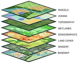
This course transforms students into proficient Geo-spatial Analysts by merging the theory of Earth observation with hands-on technical mastery. Moving beyond basic mapping, students will engage in a competence-led curriculum designed to solve complex spatial problems. You will master the full lifecycle of a GIS project: from capturing high-precision field data via GPS and Remote Sensing, to architecting robust Geo-databases and performing advanced Spatial Analysis in ArcGIS.
The core of this course is evidence-based decision-making. You will learn to synthesize "where" and "what" to address critical 21st-century challenges—such as sustainable urban expansion, natural resource depletion, and socio-economic inequality. Through collaborative "Design-Build" projects and digital image processing, you will develop the technical agility and critical thinking required for professional practice in modern planning and environmental consultancy.
- Teacher: LUTALO BERNARD